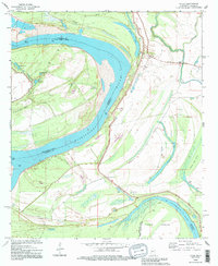
1994 Map of Fitler
USGS Topo · Published 1995About this map
The Mississippi River creates a dynamic border between Issaquena County, Mississippi and East Carroll Parish, Louisiana, defining a landscape of oxbow lakes and alluvial plains. Small settlements like Fitler and Magna Vista are situated behind the prominent levee system that protects the fertile lowlands. The geography is dominated by water features representing former river channels, including Fitler Lake, Albemarle Lake, and the winding Steele Bayou.
Find a feature on this map
28 named features on this map. Tap any name to fly to it.
Don’t see what you’re looking for? This feature index may not catch every label — zoom into the map to look around manually.
Map Details
Editions of this 1994 Fitler Map
This is the sole edition of this map. No revisions or reprints were ever made.
Other maps of this area

1909 · Lake Providence
USGS Topo · 1:24,000

1911 · Lake Providence
USGS Topo · 1:31,680

1939 · Onward
USGS Topo · 1:62,500

1939 · Lorenzen
USGS Topo · 1:62,500

1939 · Alsatia
USGS Topo · 1:62,500

1939 · Mayersville
USGS Topo · 1:62,500

1955 · Jackson
USGS Topo · 1:250,000

1961 · Jackson
USGS Topo · 1:250,000

1962 · Jackson
USGS Topo · 1:250,000

1963 · Onward
USGS Topo · 1:62,500