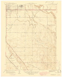
1941 Map of Fitzsimons
USGS Topo · Published 1941About this map
Fitzsimons General Hospital U S Military Reservation dominates the northern landscape of this Arapahoe County survey, marking a significant military presence on the Colorado plains just before the United States entered World War II. The map reveals a transition from the established military grounds and suburban edges to the east, where the Lowry Field Bombing Range No 2 Military Reservation reflects the era's expanding defense requirements.
Find a feature on this map
28 named features on this map. Tap any name to fly to it.
Don’t see what you’re looking for? This feature index may not catch every label — zoom into the map to look around manually.
Map Details
Editions of this 1941 Fitzsimons Map
2 editions found
Other maps of this area

1890 · East Denver
USGS Topo · 1:125,000

1935 · East Denver Nos. 3 and 4
USGS Topo · 1:48,000

1938 · Derby
USGS Topo · 1:24,000

1938 · Long Branch
USGS Topo · 1:24,000

1939 · Coal Creek
USGS Topo · 1:24,000

1940 · Englewood
USGS Topo · 1:31,680

1940 · Piney Creek
USGS Topo · 1:24,000

1940 · Derby
USGS Topo · 1:31,680

1941 · Long Branch
USGS Topo · 1:31,680

1941 · Fitzsimons
USGS Topo · 1:31,680