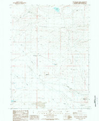
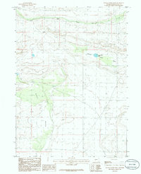
1988 Map of Five Fingers Butte
USGS Topo · Published 1989About this map
Cyclone Rim dominates the upper half of this high-desert landscape in Sweetwater County, marking a significant topographic divide where the terrain drops toward the drainage basins of Red Creek and Bear Creek. In this arid interior of Wyoming during the late 1980s, water sources like Kinch McKinney Spring and Osborne Spring were vital points of orientation for land management and cattle ranching. The presence of the John Hay Reservoir in the southwest corner and Scotty Lake to the north further illustrates the reliance on both natural and man-made water storage in this section of the Great Divide Basin. Named features like Five Fingers Butte and Bastard Butte serve as stark landmarks across the open range, while the inclusion of the Bastard Butte Well highlights the ongoing search for subsurface resources in a region defined by its wide, wind-swept basins and isolated geologic formations.
Find a feature on this map
12 named features on this map. Tap any name to fly to it.
Don’t see what you’re looking for? This feature index may not catch every label — zoom into the map to look around manually.
Map Details
Editions of this 1988 Five Fingers Butte Map
This is the sole edition of this map. No revisions or reprints were ever made.
Other maps of this area

1955 · Lander
USGS Topo · 1:250,000

1958 · Lander
USGS Topo · 1:250,000

1958 · Circle Bar Lake
USGS Topo · 1:24,000

1958 · The Pinnacles
USGS Topo · 1:62,500

1960 · Five Fingers Butte
USGS Topo · 1:62,500

1961 · Lander
USGS Topo · 1:250,000
1961 · Picket Lake
USGS Topo · 1:24,000
1961 · Sulphur Bar Spring
USGS Topo · 1:24,000
1984 · South Pass
USGS Topo · 1:100,000
1986 · Buffalo Hump Basin
USGS Topo · 1:24,000