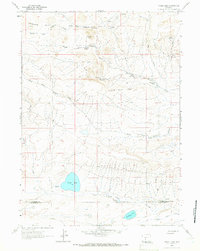
1961 Map of Picket Lake
USGS Topo · Published 1966About this map
Antelope Hills and the high desert terrain of the High Plains dominate this 1961 survey, revealing a landscape defined by seasonal water sources and sheep or cattle ranching infrastructure. The county line between Fremont Co and Sweetwater Co cuts across the southern portion of the sheet, where low-lying basins hold Picket Lake and Mc Kay Lake. The prominence of St Marys Peak and the long expanse of Horse Track Ridge guide the drainage of the complex Sulphur Creek system, including its North, Middle, and South forks.
Find a feature on this map
23 named features on this map. Tap any name to fly to it.
Don’t see what you’re looking for? This feature index may not catch every label — zoom into the map to look around manually.
Map Details
Editions of this 1961 Picket Lake Map
2 editions found
Other maps of this area

1953 · Lewiston Lakes
USGS Topo · 1:24,000

1953 · Barras Springs
USGS Topo · 1:24,000

1953 · Radium Springs
USGS Topo · 1:24,000

1955 · Lander
USGS Topo · 1:250,000

1958 · Lander
USGS Topo · 1:250,000

1958 · Circle Bar Lake
USGS Topo · 1:24,000

1958 · The Pinnacles
USGS Topo · 1:62,500

1960 · Five Fingers Butte
USGS Topo · 1:62,500

1961 · Lander
USGS Topo · 1:250,000
1961 · Sulphur Bar Spring
USGS Topo · 1:24,000