
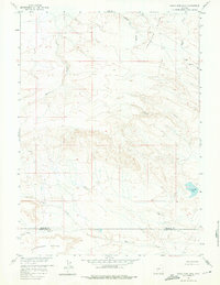
1958 Map of Circle Bar Lake
USGS Topo · Published 1960About this map
Honeycomb Buttes and the high-elevation Antelope Hills define this remote landscape along the border of Fremont and Sweetwater Counties. Surveyed for the development of the Missouri River Basin in the late 1950s, the terrain is characterized by complex drainage networks and arid landforms. Water is scarce but prominent when present, notably at Circle Bar Lake and along seasonal courses such as Sand Creek, Red Creek, and Picket Creek. The area is largely undeveloped, with human activity limited to a sparse network of a Jeep Trail winding through the hills and sloughs. These features imply a region utilized primarily for grazing or resource management rather than permanent settlement. The intricate contour work illustrates the transition from the jagged buttes in the south to the more gradual slopes of the Buffalo Gulch and Sulphur Creek drainages to the north.
Find a feature on this map
13 named features on this map. Tap any name to fly to it.
Don’t see what you’re looking for? This feature index may not catch every label — zoom into the map to look around manually.
Map Details
Editions of this 1958 Circle Bar Lake Map
2 editions found
Other maps of this area

1953 · Lewiston Lakes
USGS Topo · 1:24,000

1953 · Radium Springs
USGS Topo · 1:24,000

1953 · Atlantic City
USGS Topo · 1:24,000

1955 · Lander
USGS Topo · 1:250,000

1958 · Lander
USGS Topo · 1:250,000

1958 · The Pinnacles
USGS Topo · 1:62,500

1958 · Continental Peak
USGS Topo · 1:24,000

1960 · Five Fingers Butte
USGS Topo · 1:62,500

1961 · Lander
USGS Topo · 1:250,000
1961 · Picket Lake
USGS Topo · 1:24,000