
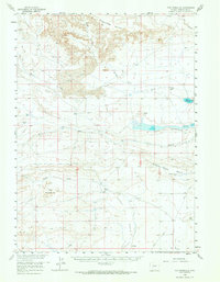
1958 Map of The Pinnacles
USGS Topo · Published 1960About this map
The High Desert of Sweetwater County is dominated by the geological formations of Honeycomb Buttes and the striking landscape of The Pinnacles. This mid-century survey shows a sparsely populated ranching landscape where water is the primary concern, evidenced by numerous named wells and catchments. The Bar X Ranch serves as a central landmark in a region defined by extensive Sand Dunes and seasonal watercourses like North Fork Bear Creek and Bush Creek.
Find a feature on this map
25 named features on this map. Tap any name to fly to it.
Don’t see what you’re looking for? This feature index may not catch every label — zoom into the map to look around manually.
Map Details
Editions of this 1958 The Pinnacles Map
2 editions found
Other maps of this area

1954 · Rock Springs
USGS Topo · 1:250,000

1955 · Lander
USGS Topo · 1:250,000

1958 · Lander
USGS Topo · 1:250,000

1958 · Rock Springs
USGS Topo · 1:250,000

1958 · Twelvemile Well
USGS Topo · 1:62,500

1958 · Circle Bar Lake
USGS Topo · 1:24,000

1958 · Freighter Gap
USGS Topo · 1:62,500

1958 · Superior
USGS Topo · 1:62,500

1958 · Dickie Springs
USGS Topo · 1:24,000

1958 · Continental Peak
USGS Topo · 1:24,000