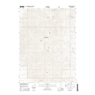
2015 Map of Five Fingers
USGS Topo · Published 2015About this map
Humboldt National Forest encompasses this section of the Santa Rosa Range, a high-elevation landscape defined by steep drainages and prominent peaks. The namesake Five Fingers and the towering Paradise Peak dominate the topography, anchoring a series of complex canyons including Buffalo Canyon and Falls Canyon. The drainage network is dense, with named waters like Stone House Cr, Wash O'Neal Cr, and Woodman Cr flowing from the heights. Historically significant springs, such as Carex Spring and Fry Spring, provide critical water points in this arid high-country environment. Human infrastructure is minimal, represented primarily by the winding path of Abel Creek Rd, illustrating the preservation of this area for wilderness and resource management during the early twenty-first century.
Find a feature on this map
30 named features on this map. Tap any name to fly to it.
Don’t see what you’re looking for? This feature index may not catch every label — zoom into the map to look around manually.
Map Details
Editions of this 2015 Five Fingers Map
This is the sole edition of this map. No revisions or reprints were ever made.
Other maps of this area

1882 · Paradise
USGS Topo · 1:250,000

1893 · Paradise
USGS Topo · 1:250,000

1955 · McDermitt
USGS Topo · 1:250,000

1958 · Paradise Valley
USGS Topo · 1:62,500

1958 · Awakening Peak
USGS Topo · 1:62,500

1959 · McDermitt
USGS Topo · 1:250,000

1959 · Orovada
USGS Topo · 1:62,500

1959 · Hinkey Summit
USGS Topo · 1:62,500
1982 · Andorno Ranch
USGS Topo · 1:24,000
1982 · Mud Spring Canyon
USGS Topo · 1:24,000