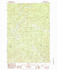
1984 Map of Five Rivers
USGS Topo · Published 1985About this map
The Alsea River and its tributary Five Rivers wind through a heavily dissected landscape within the Siuslaw National Forest during the mid-1980s. This survey focuses on the confluence of three Oregon counties—Lincoln, Benton, and Lane—revealing a remote region defined by timber-rich ridges and numerous drainages. The small settlement of Paris stands near the southern edge of the map, while river-access points like Denzer Bridge and the Blackberry Campground indicate the area's importance for local navigation and recreation. The terrain is marked by prominent elevations such as Denzer Ridge and Seits Ridge, which separate the myriad creek systems including Lobster Creek and Fendall Creek. The map documents a moment when logging roads and natural waterways provided the primary infrastructure through the steep coast range topography.
Find a feature on this map
58 named features on this map. Tap any name to fly to it.
Don’t see what you’re looking for? This feature index may not catch every label — zoom into the map to look around manually.
Map Details
Editions of this 1984 Five Rivers Map
This is the sole edition of this map. No revisions or reprints were ever made.
Other maps of this area

1918 · Mapleton
USGS Topo · 1:48,000

1940 · Mapleton
USGS Topo · 1:62,500

1941 · Blachly
USGS Topo · 1:62,500

1942 · Alsea
USGS Topo · 1:62,500

1942 · Blachly
USGS Topo · 1:62,500

1942 · Tidewater
USGS Topo · 1:62,500

1945 · Mapleton
USGS Topo · 1:62,500

1953 · Salem
USGS Topo · 1:250,000

1954 · Salem
USGS Topo · 1:250,000

1956 · Alsea
USGS Topo · 1:62,500