
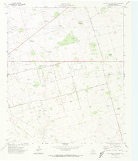
1971 Map of Five Wells Ranch
USGS Topo · Published 1974About this map
Five Wells Ranch serves as the focal point for this section of Andrews County, where the High Plains landscape is defined by the intersection of ranching traditions and the mid-century petroleum industry. The terrain is etched by the courses of Seminole Draw, Monument Draw, and Mustang Draw, which provide natural drainage across an otherwise level expanse. By the early 1970s, the region was heavily developed for mineral extraction, as evidenced by the sprawling networks of the North Hutex Oil Field, the Hutex Oil Field, and the Magutex Oil Field.
Find a feature on this map
27 named features on this map. Tap any name to fly to it.
Don’t see what you’re looking for? This feature index may not catch every label — zoom into the map to look around manually.
Map Details
Editions of this 1971 Five Wells Ranch Map
This is the sole edition of this map. No revisions or reprints were ever made.
Other maps of this area

1954 · Hobbs
USGS Topo · 1:250,000

1958 · Hobbs
USGS Topo · 1:250,000

1966 · Scharbauer Ranch
USGS Topo · 1:24,000

1966 · Bird Ranch
USGS Topo · 1:24,000

1970 · Cedar Point Ranch
USGS Topo · 1:24,000

1970 · Patricia SW
USGS Topo · 1:24,000

1970 · McKenzie Lake SE
USGS Topo · 1:24,000

1971 · Five Wells Ranch NW
USGS Topo · 1:24,000

1971 · Five Wells Ranch SE
USGS Topo · 1:24,000
1971 · Five Wells Ranch SW
USGS Topo · 1:24,000