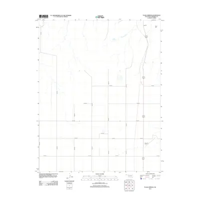
2012 Map of Flagg Springs
USGS Topo · Published 2012About this map
Flagg Springs anchors this high plains landscape in the Oklahoma Panhandle, where the intermittent Flagg Springs Cr cuts through the prairie toward the northeast. The terrain is defined by a rigid section-line grid of rural roads, including N0220 Rd and E0160 Rd, reflecting the systematic land division of Cimarron County. In the northeast corner, the elevation rises slightly at Wolf Mtn, a distinct topographic landmark in an otherwise largely flat expanse. This area serves as an essential aviation corridor for the region, evidenced by the presence of the Boise City Airport in the southeastern quadrant. The map reveals a landscape primarily dedicated to agriculture and transit, with long-established property lines and drainage patterns that have dictated local land use for generations.
Find a feature on this map
17 named features on this map. Tap any name to fly to it.
Don’t see what you’re looking for? This feature index may not catch every label — zoom into the map to look around manually.
Map Details
Editions of this 2012 Flagg Springs Map
This is the sole edition of this map. No revisions or reprints were ever made.
Other maps of this area

1954 · Dalhart
USGS Topo · 1:250,000

1958 · Dalhart
USGS Topo · 1:250,000

1962 · Dalhart
USGS Topo · 1:250,000

1968 · Autograph Cliff NW
USGS Topo · 1:24,000

1969 · Boise City
USGS Topo · 1:24,000

1969 · Boise City NW
USGS Topo · 1:24,000

1969 · Flagg Springs
USGS Topo · 1:24,000
1969 · Autograph Cliff
USGS Topo · 1:24,000
1969 · Razor Blade Mesa
USGS Topo · 1:24,000

1971 · Keyes SW
USGS Topo · 1:24,000