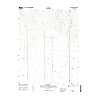
2016 Map of Flagg Springs
USGS Topo · Published 2016About this map
Flagg Springs and its surrounding high plains in Cimarron County represent the characteristic landscape of the Oklahoma Panhandle as it appeared in 2016. The map reveals an expansive area defined by deep seasonal drainages and topographic landmarks such as Wolf Mtn and French Draw. The settlement pattern follows a rigid north-south and east-west grid of rural roads, including n0230 RD and e0150 RD, reflecting the section-line system that dominates this part of the state. Near the eastern edge, the corridor for highway 287 385 provides a primary transit link north of Boise City, passing near the Boise City Airport. This survey provides a precise look at the hydrology of the area, tracing the course of Flagg Springs Cr and the low-lying Adobe Draw through the high-elevation terrain.
Find a feature on this map
19 named features on this map. Tap any name to fly to it.
Don’t see what you’re looking for? This feature index may not catch every label — zoom into the map to look around manually.
Map Details
Editions of this 2016 Flagg Springs Map
This is the sole edition of this map. No revisions or reprints were ever made.
Other maps of this area

1954 · Dalhart
USGS Topo · 1:250,000

1958 · Dalhart
USGS Topo · 1:250,000

1962 · Dalhart
USGS Topo · 1:250,000

1968 · Autograph Cliff NW
USGS Topo · 1:24,000

1969 · Boise City
USGS Topo · 1:24,000

1969 · Boise City NW
USGS Topo · 1:24,000

1969 · Flagg Springs
USGS Topo · 1:24,000
1969 · Autograph Cliff
USGS Topo · 1:24,000
1969 · Razor Blade Mesa
USGS Topo · 1:24,000

1971 · Keyes SW
USGS Topo · 1:24,000