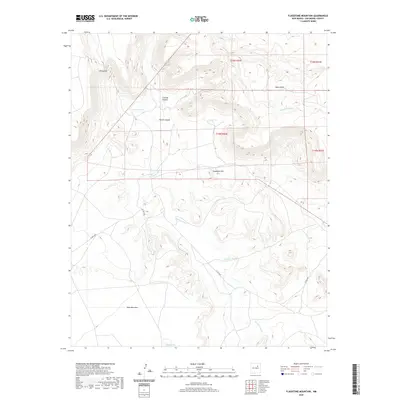
2020 Map of Flagstone Mountain
USGS Topo · Published 2020About this map
The Conchas River carves a winding path through this corner of San Miguel County, defining a landscape dominated by dramatic mesas and deep canyons. To the north, Yegua Mesa and Vivian Hill overlook the complex drainage systems of Harris Canyon and Conchas Canyon. This arid ranching country is marked by essential water management features like Harris Tank and the southern Nafas Lake, which support life between the high plateaus. The topography is anchored by the prominent Flagstone Mtn and the broad expanse of Mesa Montosa to the southwest. Modern accessibility is provided by Co RD c48a, which navigates the uneven terrain where Cañada Tuloso and Salitre Cr eventually contribute to the regional watershed.
Find a feature on this map
16 named features on this map. Tap any name to fly to it.
Don’t see what you’re looking for? This feature index may not catch every label — zoom into the map to look around manually.
Map Details
Editions of this 2020 Flagstone Mountain Map
This is the sole edition of this map. No revisions or reprints were ever made.
Other maps of this area

1892 · Watrous
USGS Topo · 1:125,000

1892 · Corazon
USGS Topo · 1:125,000

1894 · Corazon
USGS Topo · 1:125,000

1894 · Watrous
USGS Topo · 1:125,000

1954 · Santa Fe
USGS Topo · 1:250,000

1958 · Santa Fe
USGS Topo · 1:250,000

1963 · Cactus Tank
USGS Topo · 1:24,000
1963 · Chaperito
USGS Topo · 1:24,000

1963 · Flagstone Mountain
USGS Topo · 1:24,000
1963 · Mesa Lauriano
USGS Topo · 1:24,000