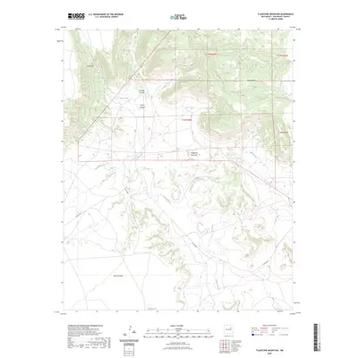
2023 Map of Flagstone Mountain
USGS Topo · Published 2023About this map
Flagstone Mountain rises as a central landmark in this high-desert reach of San Miguel County, where the intricate drainage of the Conchas River carves through the local mesa country. The map documents a landscape defined by dramatic elevation shifts, ranging from the prominent heights of Yegua Mesa and Mesa Montosa to the deep incisions of Harris Canyon and Conchas Canyon. These natural features dictate the passage of Co RD c48a, the primary artery winding through the southern half of the quadrangle. While the terrain is dominated by watercourses and ridges like Vivian Hill, evidence of human activity is found in features like Harris Tank, vital for water management in this arid environment. To the southeast, the terrain softens slightly as the river passes near Nafas Lake and receives flow from Saltire Creek, illustrating the complex hydrography of the New Mexico plains.
Find a feature on this map
16 named features on this map. Tap any name to fly to it.
Don’t see what you’re looking for? This feature index may not catch every label — zoom into the map to look around manually.
Map Details
Editions of this 2023 Flagstone Mountain Map
This is the sole edition of this map. No revisions or reprints were ever made.
Other maps of this area

1892 · Watrous
USGS Topo · 1:125,000

1892 · Corazon
USGS Topo · 1:125,000

1894 · Corazon
USGS Topo · 1:125,000

1894 · Watrous
USGS Topo · 1:125,000

1954 · Santa Fe
USGS Topo · 1:250,000

1958 · Santa Fe
USGS Topo · 1:250,000

1963 · Cactus Tank
USGS Topo · 1:24,000
1963 · Chaperito
USGS Topo · 1:24,000

1963 · Flagstone Mountain
USGS Topo · 1:24,000
1963 · Mesa Lauriano
USGS Topo · 1:24,000