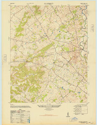
1948 Map of Flaherty
USGS Topo · Published 1948About this map
St Martins Church Cem and School serves as a central landmark for the settlement of Flaherty, anchoring a landscape defined by small rural hubs and agricultural valleys just after the Second World War. The terrain is marked by significant karst topography, with numerous sinkholes and depressions visible throughout the drainage basins of Otter Creek and Brushy Fork. This 1948 military-to-civilian reprint reveals a network of community institutions, including Salem School and Miller School, alongside family-named locales like Neilton Corner. A portion of the northeast quadrant is dedicated to a Military Reservation, reflecting the region's mid-century tactical importance. The road system, featuring the Elizabethtown Road and Brandenburg Road, connects these upland farming communities to larger regional centers while following the natural contours of Big Spring Valley and Howell Valley.
Find a feature on this map
31 named features on this map. Tap any name to fly to it.
Don’t see what you’re looking for? This feature index may not catch every label — zoom into the map to look around manually.
Map Details
Editions of this 1948 Flaherty Map
This is the sole edition of this map. No revisions or reprints were ever made.
Other maps of this area

1932 · Big Clifty
USGS Topo · 1:62,500

1935 · Elizabethtown
USGS Topo · 1:48,000

1936 · Vine Grove
USGS Topo · 1:62,500

1938 · Elizabethtown
USGS Topo · 1:62,500

1941 · Ekron
USGS Topo · 1:62,500

1943 · Vine Grove
USGS Topo · 1:62,500

1946 · Rock Haven
USGS Topo · 1:24,000

1946 · Fort Knox
USGS Topo · 1:24,000

1946 · Vine Grove
USGS Topo · 1:24,000

1946 · Vine Grove
USGS Topo · 1:62,500