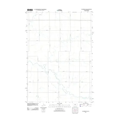
2012 Map of Flandreau NW
USGS Topo · Published 2012About this map
Big Sioux River meanders across this rural South Dakota landscape, defining the hydrology and drainage patterns of the region. The map reveals a strict section-line road network, where numbered thoroughfares like 221st St and 476th Ave carve the prairie into precise agricultural blocks. A notable point of genealogical interest is the Yeo Cem, situated north of the river near the intersection of 221st Street and 476th Avenue. To the northwest, Medary Cr flows through the corner of the quadrangle, contributing to the watershed of this expansive farming territory. This survey reflects the enduring structure of the American Midwest's land division system, where small family burial grounds and riparian corridors remain the primary landmarks amidst a landscape of high-production field crops.
Find a feature on this map
17 named features on this map. Tap any name to fly to it.
Don’t see what you’re looking for? This feature index may not catch every label — zoom into the map to look around manually.
Map Details
Editions of this 2012 Flandreau NW Map
This is the sole edition of this map. No revisions or reprints were ever made.
Other maps of this area

1953 · Watertown
USGS Topo · 1:250,000

1958 · Watertown
USGS Topo · 1:250,000

1964 · Brookings
USGS Topo · 1:24,000

1964 · Medary
USGS Topo · 1:24,000

1964 · Rutland SE
USGS Topo · 1:24,000

1964 · Flandreau SW
USGS Topo · 1:24,000

1964 · Flandreau NW
USGS Topo · 1:24,000

1964 · Aurora
USGS Topo · 1:24,000

1972 · Flandreau NE
USGS Topo · 1:24,000
1972 · White SE
USGS Topo · 1:24,000
Featured Places
- Riverview Township, SD
- Spring Creek Township, SD
- Trenton Township, SD
- Parnell Township, SD
- Brookings County, SD