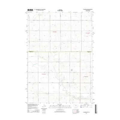
2015 Map of Flandreau NW
USGS Topo · Published 2015About this map
The Coteau des Prairies plateau defines the undulating landscape of this border region between Brookings and Moody counties. The central drainage is dominated by the meandering course of the Big Sioux River, which flows southward through the heart of the township. This agricultural area is partitioned by a rigid grid of section roads, including CR-4 and 222nd St, reflecting the persistent influence of the Public Land Survey System on South Dakota's rural development. A singular genealogical landmark, the Yeo Cem, sits in the northern portion of the quadrangle, serving as a quiet marker of the early families who settled this prairie. In the upper reaches, the smaller Medary Cr joins the larger river system, illustrating the natural water management of the glacial upland.
Find a feature on this map
26 named features on this map. Tap any name to fly to it.
Don’t see what you’re looking for? This feature index may not catch every label — zoom into the map to look around manually.
Map Details
Editions of this 2015 Flandreau NW Map
This is the sole edition of this map. No revisions or reprints were ever made.
Other maps of this area

1953 · Watertown
USGS Topo · 1:250,000

1958 · Watertown
USGS Topo · 1:250,000

1964 · Brookings
USGS Topo · 1:24,000

1964 · Medary
USGS Topo · 1:24,000

1964 · Rutland SE
USGS Topo · 1:24,000

1964 · Flandreau SW
USGS Topo · 1:24,000

1964 · Flandreau NW
USGS Topo · 1:24,000

1964 · Aurora
USGS Topo · 1:24,000

1972 · Flandreau NE
USGS Topo · 1:24,000
1972 · White SE
USGS Topo · 1:24,000
Featured Places
- Riverview Township, SD
- Spring Creek Township, SD
- Trenton Township, SD
- Parnell Township, SD
- Brookings County, SD