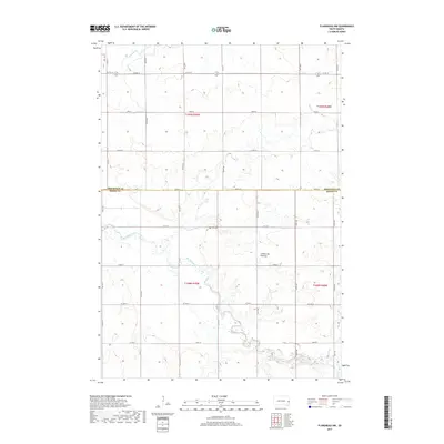
2017 Map of Flandreau NW
USGS Topo · Published 2017About this map
The Big Sioux River meanders through the fertile agricultural landscape of Riverview Township, marking the transition between Brookings and Moody counties. This portion of the Coteau des Prairies plateau is characterized by its glacial upland topography, where the natural drainage of Medary Cr feeds into the larger river system. A significant point of interest for local historians is the Yeo Cem, a small burial ground situated near the center of the survey area, which serves as a quiet reminder of the early farming families who settled this region. The section lines are clearly defined by an extensive grid of rural routes, including Co Hwy B and Co Hwy L, illustrating the structured land division that has governed South Dakota's development. This map captures the continuity of the rural prairie landscape, highlighting the vital relationship between the river valley and the surrounding townships.
Find a feature on this map
21 named features on this map. Tap any name to fly to it.
Don’t see what you’re looking for? This feature index may not catch every label — zoom into the map to look around manually.
Map Details
Editions of this 2017 Flandreau NW Map
This is the sole edition of this map. No revisions or reprints were ever made.
Other maps of this area

1953 · Watertown
USGS Topo · 1:250,000

1958 · Watertown
USGS Topo · 1:250,000

1964 · Brookings
USGS Topo · 1:24,000

1964 · Medary
USGS Topo · 1:24,000

1964 · Rutland SE
USGS Topo · 1:24,000

1964 · Flandreau SW
USGS Topo · 1:24,000

1964 · Flandreau NW
USGS Topo · 1:24,000

1964 · Aurora
USGS Topo · 1:24,000

1972 · Flandreau NE
USGS Topo · 1:24,000
1972 · White SE
USGS Topo · 1:24,000
Featured Places
- Riverview Township, SD
- Spring Creek Township, SD
- Trenton Township, SD
- Parnell Township, SD
- Brookings County, SD