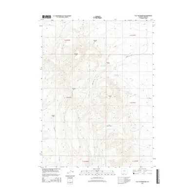
2015 Map of Flat Top Mountain
USGS Topo · Published 2015About this map
Flat Top Mtn and its neighboring peaks, North Flat Top and East Flat Top, anchor this high-desert landscape in Carbon County. The topography is defined by significant erosion patterns, with Robbers Gulch and Little Robbers Gulch carving deep pathways through the terrain. Evidence of water management for livestock or land use is visible through several numbered structures, including Detention Dam 1493 Number 1 and Detention Dam 1492 Number 8, along with Pocket Reservoir and the reliable Patterson Springs. The drainage system is intricate, with seasonal flows like Blue Gap Draw and Middle Prong Red Cr eventually feeding the N Fork Cottonwood Cr. Limited access is provided by unpaved routes such as Robber's Gulch Rd and E Hangout Rd, reflecting the remote character of this region.
Find a feature on this map
23 named features on this map. Tap any name to fly to it.
Don’t see what you’re looking for? This feature index may not catch every label — zoom into the map to look around manually.
Map Details
Editions of this 2015 Flat Top Mountain Map
This is the sole edition of this map. No revisions or reprints were ever made.
Other maps of this area

1954 · Rawlins
USGS Topo · 1:250,000

1957 · Baggs
USGS Topo · 1:62,500

1957 · Doty Mountain
USGS Topo · 1:62,500

1958 · Rawlins
USGS Topo · 1:250,000

1962 · Rawlins
USGS Topo · 1:250,000

1967 · Rawlins
USGS Topo · 1:250,000

1970 · South Barrel Spring
USGS Topo · 1:24,000

1970 · Mexican Flats
USGS Topo · 1:24,000
1970 · Flat Top Mountain
USGS Topo · 1:24,000
1970 · Dripping Rock Spring
USGS Topo · 1:24,000