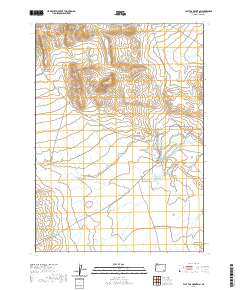
2020 Map of Flat Top Mountain
USGS Topo · Published 2020About this map
Flat Top Mtn serves as a central landmark in this high-desert region of southeastern Oregon, where the drainage patterns of Crooked Cr and Wildcat Cr reveal the essential water sources of the landscape. The existence of Pothole Springs and Crooked Creek Spring indicates the critical role of groundwater in supporting local land use in this arid portion of Malheur County. Navigation through the area is defined by a network of ranch and access roads, including N Fork Ryegrass Creek Rd and Crooked Creek Range Rd, which traverse the varied topography from Bone Canyon to the eastern plains. This 2020 topographic survey emphasizes the persistent importance of natural water features like Drought Cr and Bone Cr in defining movement and settlement boundaries across the high plateau.
Find a feature on this map
17 named features on this map. Tap any name to fly to it.
Don’t see what you’re looking for? This feature index may not catch every label — zoom into the map to look around manually.
Map Details
Editions of this 2020 Flat Top Mountain Map
This is the sole edition of this map. No revisions or reprints were ever made.
Other maps of this area

1955 · Jordan Valley
USGS Topo · 1:250,000

1955 · Adel
USGS Topo · 1:250,000

1957 · Adel
USGS Topo · 1:250,000

1957 · Jordan Valley
USGS Topo · 1:250,000

1958 · Adel
USGS Topo · 1:250,000

1958 · Jordan Valley
USGS Topo · 1:250,000

1962 · Adel
USGS Topo · 1:250,000

1972 · Palomino Hills
USGS Topo · 1:24,000
1972 · Burns Junction
USGS Topo · 1:24,000

1979 · Anderson Reservoir
USGS Topo · 1:24,000