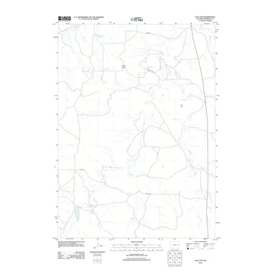
2012 Map of Flat Top
USGS Topo · Published 2012About this map
The Lightning Creek Oil Field and the surrounding drainage basins define this portion of Niobrara County. This 2012 survey reveals a landscape of ranching and energy extraction, centered on the prominent Flat Top terrain feature. The area is heavily defined by its water management and seasonal hydrology, including the Miller Number 1 Reservoir and a complex network of streams such as Lance Cr, Middle Cr, and Wyatte Cr. Local infrastructure is represented by rural connectors like Coffey Rd and Nelson Rd, which traverse the high plains to service the oil operations and remote homesteads. The branching of Little Boggy Cr and the N Fork Wyatte Cr illustrate the intricate natural drainage system that has dictated land use and property boundaries in this corner of Wyoming.
Find a feature on this map
15 named features on this map. Tap any name to fly to it.
Don’t see what you’re looking for? This feature index may not catch every label — zoom into the map to look around manually.
Map Details
Editions of this 2012 Flat Top Map
This is the sole edition of this map. No revisions or reprints were ever made.
Other maps of this area

1954 · Torrington
USGS Topo · 1:250,000

1955 · Newcastle
USGS Topo · 1:250,000

1958 · Torrington
USGS Topo · 1:250,000

1958 · Newcastle
USGS Topo · 1:250,000

1970 · Cooley Draw
USGS Topo · 1:24,000

1970 · Keeline
USGS Topo · 1:24,000
1981 · Rabbit Mountains
USGS Topo · 1:24,000

1981 · Manville
USGS Topo · 1:24,000

1981 · Bills Creek
USGS Topo · 1:24,000
1981 · Manville NE
USGS Topo · 1:24,000