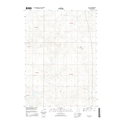
2015 Map of Flat Top
USGS Topo · Published 2015About this map
Flat Top stands as a prominent landmark in this Niobrara County landscape, surrounded by a complex network of ephemeral waterways and high prairie terrain. The map detail highlights the ranching infrastructure of the region, anchored by the Miller Number 4 Reservoir and a system of local tracks including Nelson Rd and Coffey Rd. Topographical features such as the Hamilton Hills and Horseshoe Hills define the western reaches, while the drainage systems of Lance Cr, Little Lightning Cr, and Wyatte Cr carve through the plains. This 2015 survey reflects the contemporary land use patterns of eastern Wyoming, where wide-open spaces are segmented by section lines and remote access roads serving the high-country range.
Find a feature on this map
20 named features on this map. Tap any name to fly to it.
Don’t see what you’re looking for? This feature index may not catch every label — zoom into the map to look around manually.
Map Details
Editions of this 2015 Flat Top Map
This is the sole edition of this map. No revisions or reprints were ever made.
Other maps of this area

1954 · Torrington
USGS Topo · 1:250,000

1955 · Newcastle
USGS Topo · 1:250,000

1958 · Torrington
USGS Topo · 1:250,000

1958 · Newcastle
USGS Topo · 1:250,000

1970 · Cooley Draw
USGS Topo · 1:24,000

1970 · Keeline
USGS Topo · 1:24,000
1981 · Rabbit Mountains
USGS Topo · 1:24,000

1981 · Manville
USGS Topo · 1:24,000

1981 · Bills Creek
USGS Topo · 1:24,000
1981 · Manville NE
USGS Topo · 1:24,000