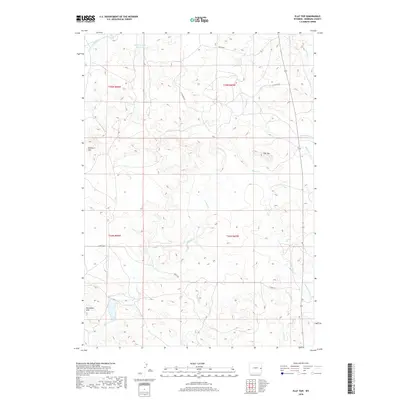
2018 Map of Flat Top
USGS Topo · Published 2018About this map
Lance Cr and its numerous tributaries, including Middle Cr, Wyatte Cr, and Boggy Cr, define the drainage patterns of this high plains region in Niobrara County. The landscape is characterized by prominent elevation markers such as Flat Top and the Hamilton Hills in the west, which rise above the surrounding prairie. Infrastructure in this era remains largely rural and sparse, consisting of ranch-to-market roads like Coffey Rd, Nelson Rd, and V-S Hilltop Rd. For those interested in local water management and land use, the Miller Number 1 Reservoir stands as a significant man-made feature in the northern portion of the quadrangle. The map captures a section of the American West where traditional township and range divisions, such as t35n r66w, still dictate the organization of the vast open range.
Find a feature on this map
20 named features on this map. Tap any name to fly to it.
Don’t see what you’re looking for? This feature index may not catch every label — zoom into the map to look around manually.
Map Details
Editions of this 2018 Flat Top Map
This is the sole edition of this map. No revisions or reprints were ever made.
Other maps of this area

1954 · Torrington
USGS Topo · 1:250,000

1955 · Newcastle
USGS Topo · 1:250,000

1958 · Torrington
USGS Topo · 1:250,000

1958 · Newcastle
USGS Topo · 1:250,000

1970 · Cooley Draw
USGS Topo · 1:24,000

1970 · Keeline
USGS Topo · 1:24,000
1981 · Rabbit Mountains
USGS Topo · 1:24,000

1981 · Manville
USGS Topo · 1:24,000

1981 · Bills Creek
USGS Topo · 1:24,000
1981 · Manville NE
USGS Topo · 1:24,000