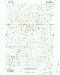
1981 Map of Flat Top
USGS Topo · Published 1981About this map
The Lightning Creek Oil Field defines the industrial character of this eastern Wyoming landscape, marked by a dense network of Well and Oil Well sites interspersed with numerous exploratory Drill Hole locations. The terrain is dominated by the Hamilton Hills to the west and the prominent Flat Top elevation to the northeast, creating a high-plains environment where drainage is managed through intermittent streams like Little Lightning Creek and Boggy Creek. In the southwest, water resources are concentrated around the Joss Reservoir and along the banks of Lance Creek, where remote Landing Strips provide essential access to this working landscape. The map captures the specialized infrastructure of the energy industry as it integrated into the Niobrara County ranchlands during the early 1980s, showcasing the intersection of natural topography and resource extraction.
Find a feature on this map
15 named features on this map. Tap any name to fly to it.
Don’t see what you’re looking for? This feature index may not catch every label — zoom into the map to look around manually.
Map Details
Editions of this 1981 Flat Top Map
This is the sole edition of this map. No revisions or reprints were ever made.
Other maps of this area

1954 · Torrington
USGS Topo · 1:250,000

1955 · Newcastle
USGS Topo · 1:250,000

1958 · Torrington
USGS Topo · 1:250,000

1958 · Newcastle
USGS Topo · 1:250,000

1970 · Cooley Draw
USGS Topo · 1:24,000

1970 · Keeline
USGS Topo · 1:24,000
1981 · Rabbit Mountains
USGS Topo · 1:24,000

1981 · Manville
USGS Topo · 1:24,000

1981 · Bills Creek
USGS Topo · 1:24,000
1981 · Manville NE
USGS Topo · 1:24,000