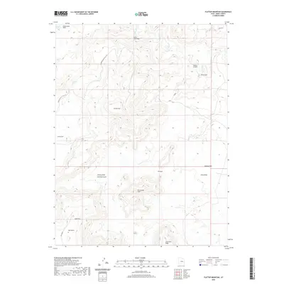
2020 Map of Flattop Mountain
USGS Topo · Published 2020About this map
Dinosaur Quarry & Flat Top defines the northwest corner of this high-elevation landscape in Emery County. The terrain is characterized by a complex network of canyons and washes, with the Price River cutting through the northeast, creating deep incisions like Sulphur Canyon and Stove Gulch. Dominant landmarks such as Flattop Mtn and Cedar Mtn provide significant vertical relief, while flat-topped features like Huff Bench and Humbug Flats suggest a plateau structure dissected by erosion.
Find a feature on this map
21 named features on this map. Tap any name to fly to it.
Don’t see what you’re looking for? This feature index may not catch every label — zoom into the map to look around manually.
Map Details
Editions of this 2020 Flattop Mountain Map
This is the sole edition of this map. No revisions or reprints were ever made.
Other maps of this area

1886 · Price River
USGS Topo · 1:250,000

1896 · Price River
USGS Topo · 1:250,000

1948 · Woodside
USGS Topo · 1:62,500

1949 · Woodside
USGS Topo · 1:62,500

1950 · Woodside
USGS Topo · 1:62,500

1956 · Price
USGS Topo · 1:250,000

1960 · Price
USGS Topo · 1:250,000

1962 · Price
USGS Topo · 1:250,000
1969 · Dry Mesa
USGS Topo · 1:24,000

1969 · Olsen Reservoir
USGS Topo · 1:24,000