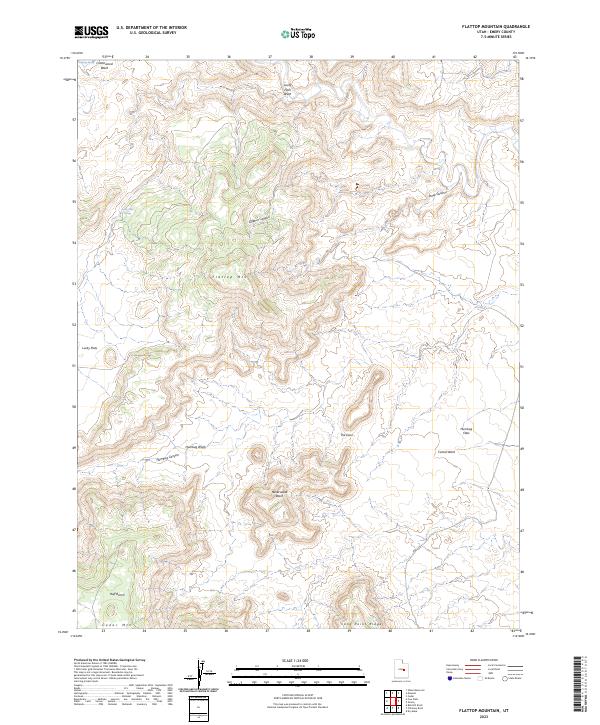
2023 Map of Flattop Mountain
USGS Topo · Published 2023About this map
Flattop Mtn dominates this high-elevation landscape in Emery County, serving as a central point for a complex network of arid drainages and naming-conventions that reflect the dry, demanding nature of the Utah interior. The map illustrates a topography defined by steep-walled breaks and extensive plateaus, such as Huff Bench and Long Point Ridge, which flank the higher summits. Water sources are precious and specifically noted, including Dripping Spring and Lucky Flats Spring, which likely served as critical landmarks for early travelers and livestock. To the south and east, the terrain opens into broader expanses like Lucky Flats and Humbug Flats, while the erosional power of the region is evident in the deep incisions of Sulphur Canyon, Humbug Canyon, and Neversweat Wash. Unique landforms like The Door suggest narrow passages through the sandstone rimrock, typical of the San Rafael Swell area's geological character.
Find a feature on this map
17 named features on this map. Tap any name to fly to it.
Don’t see what you’re looking for? This feature index may not catch every label — zoom into the map to look around manually.
Map Details
Editions of this 2023 Flattop Mountain Map
This is the sole edition of this map. No revisions or reprints were ever made.
Other maps of this area

1886 · Price River
USGS Topo · 1:250,000

1896 · Price River
USGS Topo · 1:250,000

1948 · Woodside
USGS Topo · 1:62,500

1949 · Woodside
USGS Topo · 1:62,500

1950 · Woodside
USGS Topo · 1:62,500

1956 · Price
USGS Topo · 1:250,000

1960 · Price
USGS Topo · 1:250,000

1962 · Price
USGS Topo · 1:250,000
1969 · Dry Mesa
USGS Topo · 1:24,000

1969 · Olsen Reservoir
USGS Topo · 1:24,000