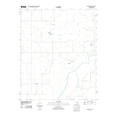
2010 Map of Fleetwood
USGS Topo · Published 2010About this map
The Red River defines the southern boundary of this Jefferson County landscape, winding through a network of small tributaries and creek basins in the years following the millennium. The rural settlements of Oscar and Fleetwood anchor a grid of county roads that navigate the varying terrain of the Oklahoma-Texas borderlands. Notable topographic features include the low-lying Sam Suell Hollow and a series of water management sites, such as the Oknoname 067014 Reservoir and Reagan Lake. The road network provides evidence of local history and infrastructure changes, including the specifically named Burned Out Bridge Rd and Red River Station Rd, the latter referencing the historic cattle crossing and frontier outpost that once served the Chisholm Trail. Numerous smaller waterways like Cat Creek, Pecan Creek, and Salt Creek dissect the plains, illustrating the drainage patterns that have shaped the ranching and agricultural development of this border region.
Find a feature on this map
45 named features on this map. Tap any name to fly to it.
Don’t see what you’re looking for? This feature index may not catch every label — zoom into the map to look around manually.
Map Details
Editions of this 2010 Fleetwood Map
This is the sole edition of this map. No revisions or reprints were ever made.
Other maps of this area

1901 · Addington
USGS Topo · 1:125,000

1905 · Montague
USGS Topo · 1:125,000

1954 · Sherman
USGS Topo · 1:250,000

1957 · Ardmore
USGS Topo · 1:250,000

1958 · Sherman
USGS Topo · 1:250,000

1962 · Ryan
USGS Topo · 1:62,500

1963 · Ardmore
USGS Topo · 1:250,000
1968 · Terral
USGS Topo · 1:24,000

1968 · Nocona
USGS Topo · 1:24,000

1968 · Fleetwood
USGS Topo · 1:24,000