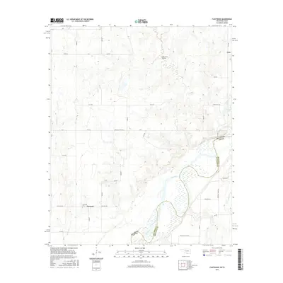
2016 Map of Fleetwood
USGS Topo · Published 2016About this map
The Red River defines the border between Jefferson County, Oklahoma, and Montague County, Texas, snaking through a landscape of broad floodplains and intermittent stream crossings. The small settlement of Fleetwood is centered around the Fleetwood Cem, while the community of Oscar sits near the northeastern corner of the map. The terrain is characterized by numerous small drainages such as Cat Cr, Pecan Cr, and Fleetwood Cr, alongside named landforms like Sam Suell Hollow. The road network reflects a history of river access and rural transit, featuring paths like Red River Station Rd and the evocatively named Burned Out Bridge Rd. This survey documents the wetlands and complex oxbows typical of this riverine boundary, including small bodies of water like Reagan Lake.
Find a feature on this map
37 named features on this map. Tap any name to fly to it.
Don’t see what you’re looking for? This feature index may not catch every label — zoom into the map to look around manually.
Map Details
Editions of this 2016 Fleetwood Map
This is the sole edition of this map. No revisions or reprints were ever made.
Other maps of this area

1901 · Addington
USGS Topo · 1:125,000

1905 · Montague
USGS Topo · 1:125,000

1954 · Sherman
USGS Topo · 1:250,000

1957 · Ardmore
USGS Topo · 1:250,000

1958 · Sherman
USGS Topo · 1:250,000

1962 · Ryan
USGS Topo · 1:62,500

1963 · Ardmore
USGS Topo · 1:250,000
1968 · Terral
USGS Topo · 1:24,000

1968 · Nocona
USGS Topo · 1:24,000

1968 · Fleetwood
USGS Topo · 1:24,000