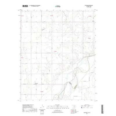
2019 Map of Fleetwood
USGS Topo · Published 2019About this map
The Red River defines the southern boundary of this landscape, separating Jefferson County, Oklahoma, from Montague County, Texas. This borderland region is characterized by an intricate network of waterways draining into the river valley, including Fleetwood Cr, Cat Cr, and Salt Cr. The small community of Fleetwood sits at a junction of rural roads near the Fleetwood Cem, while the settlement of Oscar occupies the northeastern corner of the map.
Find a feature on this map
50 named features on this map. Tap any name to fly to it.
Don’t see what you’re looking for? This feature index may not catch every label — zoom into the map to look around manually.
Map Details
Editions of this 2019 Fleetwood Map
This is the sole edition of this map. No revisions or reprints were ever made.
Other maps of this area

1901 · Addington
USGS Topo · 1:125,000

1905 · Montague
USGS Topo · 1:125,000

1954 · Sherman
USGS Topo · 1:250,000

1957 · Ardmore
USGS Topo · 1:250,000

1958 · Sherman
USGS Topo · 1:250,000

1962 · Ryan
USGS Topo · 1:62,500

1963 · Ardmore
USGS Topo · 1:250,000
1968 · Terral
USGS Topo · 1:24,000

1968 · Nocona
USGS Topo · 1:24,000

1968 · Fleetwood
USGS Topo · 1:24,000