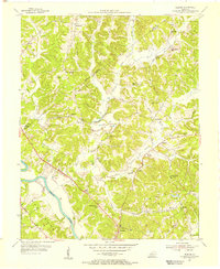
1954 Map of Flener
USGS Topo · Published 1955About this map
The Green River carves a sweeping path through the southwestern portion of this 1954 landscape, defining the rural character of the border between Ohio and Butler counties. Settlement is scattered along the winding ridges and hollows, concentrated in small hubs like Dexterville and Baizetown. The social fabric of the era is clearly visible through a high density of rural institutions, including Flener Chapel, Old McHenry Chapel, and Walnut Grove Ch, alongside numerous local schoolhouses such as Shallow Ford Sch and Lands Sch. Evidence of the region's extractive economy appears in the eastern hills near Monford, where a Strip Mine marks the terrain. The map's detailed topography, featuring locations like Cowpath Hollow and Wolfpen Hollow, illustrates the challenging, dissected plateau that shaped the transportation and agricultural patterns of these Kentucky communities in the mid-1950s.
Find a feature on this map
37 named features on this map. Tap any name to fly to it.
Don’t see what you’re looking for? This feature index may not catch every label — zoom into the map to look around manually.
Map Details
Editions of this 1954 Flener Map
This is the sole edition of this map. No revisions or reprints were ever made.
Other maps of this area

1909 · Hartford
USGS Topo · 1:62,500

1911 · Dunmor
USGS Topo · 1:48,000

1914 · Little Muddy
USGS Topo · 1:62,500

1914 · Dunmor
USGS Topo · 1:62,500

1925 · Spring Lick
USGS Topo · 1:62,500

1953 · South Hill
USGS Topo · 1:24,000

1954 · Evansville
USGS Topo · 1:250,000

1954 · Horton
USGS Topo · 1:24,000

1954 · Spring Lick
USGS Topo · 1:24,000

1954 · Welchs Creek
USGS Topo · 1:24,000