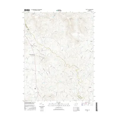
2016 Map of Flint Hill
USGS Topo · Published 2016About this map
Chester Gap and the surrounding Blue Ridge foothills defined the local landscape in 2016, where the border of Fauquier and Rappahannock counties follows the high ridgelines. High peaks like Rattlesnake Mtn and Buck Mtn overlook a complex network of narrow valleys and hollows, including the prominent Shootz Hollow. The area maintains a rural, agricultural character, with scattered settlements such as Huntly and Wakefield Manor connected by winding roads like Hume Rd and Hillsboro Rd.
Find a feature on this map
89 named features on this map. Tap any name to fly to it.
Don’t see what you’re looking for? This feature index may not catch every label — zoom into the map to look around manually.
Map Details
Editions of this 2016 Flint Hill Map
This is the sole edition of this map. No revisions or reprints were ever made.
Other maps of this area

1893 · Luray
USGS Topo · 1:125,000

1894 · Warrenton
USGS Topo · 1:125,000

1894 · Warrenton
USGS Topo · 1:62,500

1905 · Luray
USGS Topo · 1:125,000

1927 · Remington
USGS Topo · 1:48,000

1930 · Warrenton
USGS Topo · 1:62,500

1939 · Front Royal
USGS Topo · 1:48,000

1943 · Orlean
USGS Topo · 1:24,000

1943 · Upperville
USGS Topo · 1:24,000
1944 · Upperville
USGS Topo · 1:31,680