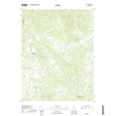
2019 Map of Flint Hill
USGS Topo · Published 2019About this map
The Rappahannock River defines the winding boundary between Fauquier and Rappahannock Counties in this portion of the Piedmont region. Small historic hamlets like Flint Hill, Huntly, and Hume anchor the rolling landscape, connected by a network of rural routes such as Co RD 635 and Hume Rd. The map reveals a land structured by its waterways and prominent peaks, with Hittles Mill Stream and the Jordan River carving paths through the terrain near the base of Oventop and Long Mtn.
Find a feature on this map
93 named features on this map. Tap any name to fly to it.
Don’t see what you’re looking for? This feature index may not catch every label — zoom into the map to look around manually.
Map Details
Editions of this 2019 Flint Hill Map
This is the sole edition of this map. No revisions or reprints were ever made.
Other maps of this area

1893 · Luray
USGS Topo · 1:125,000

1894 · Warrenton
USGS Topo · 1:125,000

1894 · Warrenton
USGS Topo · 1:62,500

1905 · Luray
USGS Topo · 1:125,000

1927 · Remington
USGS Topo · 1:48,000

1930 · Warrenton
USGS Topo · 1:62,500

1939 · Front Royal
USGS Topo · 1:48,000

1943 · Orlean
USGS Topo · 1:24,000

1943 · Upperville
USGS Topo · 1:24,000
1944 · Upperville
USGS Topo · 1:31,680