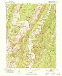
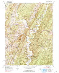
1950 Map of Flintstone
USGS Topo · Published 1972About this map
Flintstone sits at a critical gap in the Appalachian ridges where the National Pike cuts through the steep topography of Warrior Mountain and Polish Mountain. This 1950 survey captures the corridor at a time when local transport still followed the ancient water gaps of Town Creek and Flintstone Creek, with the historic Mason and Dixon Line serving as the northern boundary between Maryland and Pennsylvania. The map reveals a landscape defined by narrow hollows and high knobs, such as Grannys Knob and Betsy Knob, where small-scale industry and community life persisted in isolated pockets. Researchers can find evidence of early mineral extraction at Tussey Diggings and the vital role of local institutions at Flintstone Creek Sch and the Glendale Ch. From the ridge-top Pipe Line to the secluded Ravens Den, the map documents a transition from traditional mountain farming toward modern infrastructure.
Find a feature on this map
60 named features on this map. Tap any name to fly to it.
Don’t see what you’re looking for? This feature index may not catch every label — zoom into the map to look around manually.
Map Details
Editions of this 1950 Flintstone Map
5 editions found
Other maps of this area

1898 · Paw Paw
USGS Topo · 1:62,500

1899 · Flintstone
USGS Topo · 1:62,500

1900 · Pawpaw
USGS Topo · 1:62,500

1900 · Flintstone
USGS Topo · 1:62,500

1910 · Paw Paw
USGS Topo · 1:62,500

1927 · Clearville
USGS Topo · 1:48,000

1927 · Hyndman
USGS Topo · 1:62,500

1931 · Clearville
USGS Topo · 1:62,500

1931 · Hyndman
USGS Topo · 1:62,500

1944 · Hyndman
USGS Topo · 1:62,500