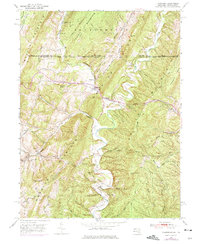
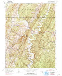
1950 Map of Flintstone
USGS Topo · Published 1975About this map
Flintstone sits at a critical junction in the Appalachian landscape, where the National Pike cuts through the ridges of Warrior Mountain and Polish Mountain. The settlement pattern follows the valley floor, anchored by the Flintstone Creek Sch and religious centers such as Glendale Ch and Oakdale Ch. The northern portion of the map is defined by the historic Mason and Dixon Line, marking the border between Pennsylvania and Maryland. To the south, the terrain becomes increasingly complex with deep cuts like Kifer Hollow and Possum Hollow draining toward Town Creek. The presence of the Odd Fellows Cem and Fairview Cem near the mountain gaps suggests long-standing rural communities that relied on these mountain passes for trade and travel along the early turnpike routes.
Find a feature on this map
53 named features on this map. Tap any name to fly to it.
Don’t see what you’re looking for? This feature index may not catch every label — zoom into the map to look around manually.
Map Details
Editions of this 1950 Flintstone Map
5 editions found
Other maps of this area

1898 · Paw Paw
USGS Topo · 1:62,500

1899 · Flintstone
USGS Topo · 1:62,500

1900 · Pawpaw
USGS Topo · 1:62,500

1900 · Flintstone
USGS Topo · 1:62,500

1910 · Paw Paw
USGS Topo · 1:62,500

1927 · Clearville
USGS Topo · 1:48,000

1927 · Hyndman
USGS Topo · 1:62,500

1931 · Clearville
USGS Topo · 1:62,500

1931 · Hyndman
USGS Topo · 1:62,500

1944 · Hyndman
USGS Topo · 1:62,500