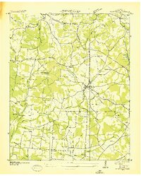
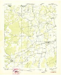
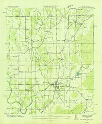
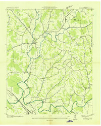
1936 Map of Flintville
USGS Topo · Published 1936About this map
Flintville serves as the focal point of this Tennessee Valley Authority and USGS collaboration, capturing the agricultural and infrastructural pulse of Lincoln County in the mid-1930s. The St Louis and Nashville Railroad cuts a diagonal path through the landscape, connecting the main village to outlying hamlets like Crystal Springs and Vanntown. The era's focus on rural modernization is evident in the sprawling network of the Electric Membership Corporation lines and the Tennessee Valley Authority Corp infrastructure, which appear alongside traditional landmarks like Brown Chapel and Lucy Memorial Ch.
Find a feature on this map
60 named features on this map. Tap any name to fly to it.
Don’t see what you’re looking for? This feature index may not catch every label — zoom into the map to look around manually.
Map Details
Editions of this 1936 Flintville Map
This is the sole edition of this map. No revisions or reprints were ever made.
Other maps of this area

1888 · Scottsboro
USGS Topo · 1:125,000

1888 · Huntsville
USGS Topo · 1:125,000

1892 · Huntsville
USGS Topo · 1:125,000

1892 · Scottsboro
USGS Topo · 1:125,000

1936 · King Cove
USGS Topo · 1:24,000

1936 · Fisk
USGS Topo · 1:24,000

1936 · Lincoln
USGS Topo · 1:24,000
1936 · Huntland
USGS Topo · 1:24,000
1936 · New Market
USGS Topo · 1:24,000
1936 · Mulberry
USGS Topo · 1:24,000