1936 Map of New Market
USGS Topo · Published 1936About this map
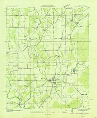
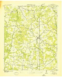
The Old Cherokee Boundary strikes a historical diagonal across this mid-1930s landscape, marking a legacy of frontier expansion where the Nashville Chattanooga and St Louis railroad now serves the valley settlements. The village of New Market stands as the primary hub, surrounded by a network of rural crossroads and family-named landmarks like Toliver and Fannings. This era of documentation reveals a community deeply rooted in its local institutions, evidenced by the dense concentration of schools and houses of worship including Hillsboro Sch and Pleasant Grove Ch.
Find a feature on this map
49 named features on this map. Tap any name to fly to it.
Don’t see what you’re looking for? This feature index may not catch every label — zoom into the map to look around manually.
Map Details
Editions of this 1936 New Market Map
This is the sole edition of this map. No revisions or reprints were ever made.
Other maps of this area

1888 · Scottsboro
USGS Topo · 1:125,000

1888 · Huntsville
USGS Topo · 1:125,000

1892 · Huntsville
USGS Topo · 1:125,000

1892 · Scottsboro
USGS Topo · 1:125,000

1936 · King Cove
USGS Topo · 1:24,000
1936 · Flintville
USGS Topo · 1:24,000

1936 · Meridianville
USGS Topo · 1:24,000

1936 · Fisk
USGS Topo · 1:24,000

1936 · Hollytree
USGS Topo · 1:24,000

1936 · Lincoln
USGS Topo · 1:24,000