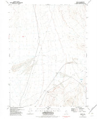
1982 Map of Floka
USGS Topo · Published 1982About this map
The Western Pacific railroad cuts through this arid landscape, passing the small station point of Floka. This area is characterized by desert terrain and mining activity along the eastern edges of the Kamma Mts. Isolated water sources like Mandalay Spring were vital in this environment, supporting both early travelers and those working the various mineral claims. The presence of several prospects and a noted mine suggests a period of intensive exploration in the hills. Distinctive geological markers, such as the prominent Pulpit Rock, served as local landmarks for those navigating the numerous 4wd tracks that spiderweb across the basin and range territory. The map reflects the specialized infrastructure required for high-desert transit and resource extraction in northern Nevada.
Find a feature on this map
10 named features on this map. Tap any name to fly to it.
Don’t see what you’re looking for? This feature index may not catch every label — zoom into the map to look around manually.
Map Details
Editions of this 1982 Floka Map
This is the sole edition of this map. No revisions or reprints were ever made.
Other maps of this area

1886 · Disaster
USGS Topo · 1:250,000

1893 · Disaster
USGS Topo · 1:250,000

1931 · Lovelock
USGS Topo · 1:250,000

1935 · Lovelock
USGS Topo · 1:250,000

1954 · Vya
USGS Topo · 1:250,000

1955 · Lovelock
USGS Topo · 1:250,000

1958 · Vya
USGS Topo · 1:250,000

1959 · Lovelock
USGS Topo · 1:250,000

1962 · Vya
USGS Topo · 1:250,000

1966 · King Lear Peak
USGS Topo · 1:62,500