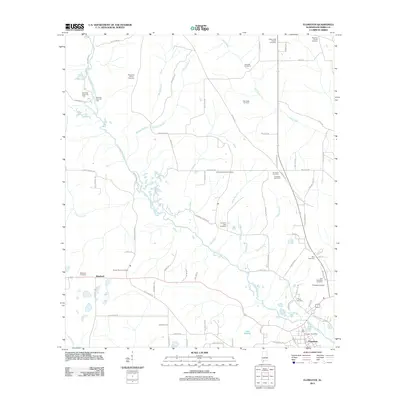
2011 Map of Flomaton
USGS Topo · Published 2011About this map
Big Escambia Creek winds through this landscape on the Alabama-Florida border, anchoring a region defined by its oil and gas resources and scattered rural settlements. Industrial footprints are visible at the Sizemore Creek Oil Field and the Hall Creek Oil Field, while the town of Flomaton serves as the local hub near the southern edge. The map captures a detailed network of family-named roads and remote burial grounds, such as Moyeville Church Cemetery and Larnbeth-Boutwell Cemetery, which offer valuable data for genealogical research. Aviation infrastructure is represented by the Flomaton Airport, situated north of the Flomaton Post Office. Small communities like Wawbeek appear along the main corridors, surrounded by a complex system of tributaries including Pond Creek and Bills Branch, reflecting the typical rural settlement pattern of Escambia County in the early 21st century.
Find a feature on this map
82 named features on this map. Tap any name to fly to it.
Don’t see what you’re looking for? This feature index may not catch every label — zoom into the map to look around manually.
Map Details
Editions of this 2011 Flomaton Map
This is the sole edition of this map. No revisions or reprints were ever made.
Other maps of this area

1941 · Century
USGS Topo · 1:62,500

1943 · Century
USGS Topo · 1:62,500

1943 · Jay
USGS Topo · 1:62,500

1953 · Andalusia
USGS Topo · 1:250,000

1957 · Andalusia
USGS Topo · 1:250,000

1957 · Pensacola
USGS Topo · 1:250,000

1959 · Pensacola
USGS Topo · 1:250,000

1960 · Pensacola
USGS Topo · 1:250,000

1960 · Atmore
USGS Topo · 1:24,000

1960 · Huxford
USGS Topo · 1:24,000