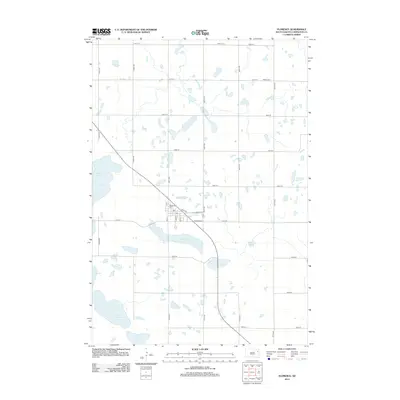
2012 Map of Florence
USGS Topo · Published 2012About this map
Florence stands as the central hub of this prairie landscape in Codington County, situated at the intersection of Co HWY-25 and the local grid. The town's layout is clearly defined by streets such as Main Ave and Thorson Ave, with a local Po serving as a community anchor. This 2012 survey illustrates a region defined by its hydrography, where numerous glacial lakes and wetlands dot the terrain. To the south of the settlement lies the elongated basin of Dry Lake, while the western edge is marked by the waters of Grass Lake and Lake Nicholson. The distribution of rural cemeteries, including Dexter Cem in the north and the nearby New Helgen Cem, suggests the historical footprint of early homesteads and the deep-rooted community ties of Fuller Township. The landscape transitions into marshy lowlands at Sumner Slough, reflecting the typical hydrology of the South Dakota plains.
Find a feature on this map
33 named features on this map. Tap any name to fly to it.
Don’t see what you’re looking for? This feature index may not catch every label — zoom into the map to look around manually.
Map Details
Editions of this 2012 Florence Map
This is the sole edition of this map. No revisions or reprints were ever made.
Other maps of this area

1953 · Milbank
USGS Topo · 1:250,000

1953 · Watertown
USGS Topo · 1:250,000

1958 · Milbank
USGS Topo · 1:250,000

1958 · Watertown
USGS Topo · 1:250,000

1969 · Watertown West
USGS Topo · 1:24,000

1970 · Lonesome Lake
USGS Topo · 1:24,000

1970 · Florence NE
USGS Topo · 1:24,000

1970 · Still Lake
USGS Topo · 1:24,000

1973 · Florence
USGS Topo · 1:24,000

1973 · Florence NW
USGS Topo · 1:24,000