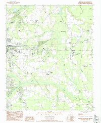
1986 Map of Florence East
USGS Topo · Published 1987About this map
Francis Marion College stands as a central landmark in this 1980s landscape east of Florence, where the transition from city suburbs to the wetlands of the Pee Dee region is clearly defined. The area is marked by a network of drainage and transport infrastructure, including the Polk Swamp Canal and the Florence City-County Airport, which serves as a major hub for the region.
Find a feature on this map
54 named features on this map. Tap any name to fly to it.
Don’t see what you’re looking for? This feature index may not catch every label — zoom into the map to look around manually.
Map Details
Editions of this 1986 Florence East Map
This is the sole edition of this map. No revisions or reprints were ever made.
Other maps of this area

1940 · Florence West
USGS Topo · 1:62,500

1940 · Florence East
USGS Topo · 1:62,500

1943 · Gum Swamp
USGS Topo · 1:62,500

1945 · Florence East
USGS Topo · 1:62,500

1945 · Florence West
USGS Topo · 1:62,500

1953 · Florence
USGS Topo · 1:250,000

1954 · Florence
USGS Topo · 1:250,000

1963 · Darlington East
USGS Topo · 1:24,000
1972 · Oak Grove
USGS Topo · 1:24,000
1972 · Witherspoon Island
USGS Topo · 1:24,000