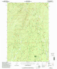
1995 Map of Florence
USGS Topo · Published 1999About this map
Florence sits at the heart of this high-altitude landscape within the Nez Perce National Forest, serving as a focal point for gold mining history in the Florence Basin. The area is characterized by a dense network of watercourses like Little Slate Creek and Little French Creek, which were central to the hydraulic mining operations of the nineteenth century. Evidence of this industrial past remains visible through labels for the Waverly Mine and numerous prospects scattered throughout the basin.
Find a feature on this map
51 named features on this map. Tap any name to fly to it.
Don’t see what you’re looking for? This feature index may not catch every label — zoom into the map to look around manually.
Map Details
Editions of this 1995 Florence Map
This is the sole edition of this map. No revisions or reprints were ever made.
Other maps of this area

1931 · Buffalo Hump
USGS Topo · 1:125,000

1934 · Buffalo Hump
USGS Topo · 1:125,000

1938 · Riggins
USGS Topo · 1:96,000

1945 · Riggins
USGS Topo · 1:125,000

1955 · Grangeville
USGS Topo · 1:250,000

1956 · Burgdorf
USGS Topo · 1:62,500

1956 · Elk City
USGS Topo · 1:250,000

1959 · Grangeville
USGS Topo · 1:250,000

1960 · Elk City
USGS Topo · 1:250,000

1963 · John Day Mtn
USGS Topo · 1:24,000