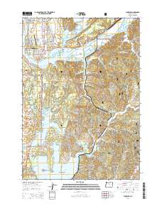
2014 Map of Florence
USGS Topo · Published 2014About this map
The Siuslaw River winds through the heart of the central Oregon coast, where the community of Florence anchors a landscape defined by expansive dunes and coastal freshwater lakes. This 2014 survey documents the intricate geography of the region, from the tidal flats of North Fork Shoal and Cox Island to the timber-related legacy visible at the Mount Canary Company Log Pond near Canary. The map reveals the relationship between early 20th-century industry and modern recreation, particularly in the vicinity of Siltcoos Lake and Woahink Lake.
Find a feature on this map
101 named features on this map. Tap any name to fly to it.
Don’t see what you’re looking for? This feature index may not catch every label — zoom into the map to look around manually.
Map Details
Editions of this 2014 Florence Map
This is the sole edition of this map. No revisions or reprints were ever made.
Other maps of this area

1918 · Mapleton
USGS Topo · 1:48,000

1919 · Earl
USGS Topo · 1:48,000

1920 · Siltcoos Lake
USGS Topo · 1:62,500

1920 · Heceta Head
USGS Topo · 1:62,500

1940 · Mapleton
USGS Topo · 1:62,500

1941 · Siltcoos Lake
USGS Topo · 1:62,500

1942 · Heceta Head
USGS Topo · 1:62,500

1942 · Siltcoos Lake
USGS Topo · 1:62,500

1943 · Goodwin Peak
USGS Topo · 1:62,500

1945 · Mapleton
USGS Topo · 1:62,500