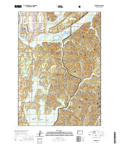
2020 Map of Florence
USGS Topo · Published 2020About this map
Florence and the surrounding Lane County coast are defined by the complex convergence of the Siuslaw River and a massive system of freshwater lakes. This 2020 edition detail the intricate estuarine environment where the North Fork Siuslaw River meets the main channel near Cushman, punctuated by landforms like Cox Island and Bull Island. To the south, the landscape shifts into the coastal dunes and timberlands of the Siuslaw National Forest, surrounding significant water bodies such as Woahink Lake and Siltcoos Lake. Local history is preserved in several burial grounds, including the Heceta Lodge Number 11 IOOF Cem and the Pacific Sunset Memorial Park Cem. The map illustrates the contemporary footprint of coastal communities like Dunes City and Westlake, alongside legacy locations such as Canary and Glenada, showing how modern infrastructure like the Florence Municipal Airport integrates with the region's natural geography.
Find a feature on this map
118 named features on this map. Tap any name to fly to it.
Don’t see what you’re looking for? This feature index may not catch every label — zoom into the map to look around manually.
Map Details
Editions of this 2020 Florence Map
This is the sole edition of this map. No revisions or reprints were ever made.
Other maps of this area

1918 · Mapleton
USGS Topo · 1:48,000

1919 · Earl
USGS Topo · 1:48,000

1920 · Siltcoos Lake
USGS Topo · 1:62,500

1920 · Heceta Head
USGS Topo · 1:62,500

1940 · Mapleton
USGS Topo · 1:62,500

1941 · Siltcoos Lake
USGS Topo · 1:62,500

1942 · Heceta Head
USGS Topo · 1:62,500

1942 · Siltcoos Lake
USGS Topo · 1:62,500

1943 · Goodwin Peak
USGS Topo · 1:62,500

1945 · Mapleton
USGS Topo · 1:62,500