
1945 Map of Florence West
USGS Topo · Published 1945About this map
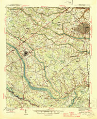
The Atlantic Coast Line and Seaboard Air Line railroads converge in this mid-century survey, anchoring a landscape defined by agricultural crossroads and small rural communities. The city of Florence occupies the northeastern corner, characterized by the Peedee Agricultural Experiment Sta and the Tuberculosis Sanitarium. To the west, Timmonsville serves as a secondary hub at the junction of rail and road, surrounded by dozens of family-named intersections like Wilson Crossroads, Jernigan Crossroads, and Hollman Crossroads.
Find a feature on this map
78 named features on this map. Tap any name to fly to it.
Don’t see what you’re looking for? This feature index may not catch every label — zoom into the map to look around manually.
Map Details
Editions of this 1945 Florence West Map
2 editions found
Other maps of this area

1920 · Mayesville
USGS Topo · 1:48,000

1921 · Mayesville
USGS Topo · 1:62,500

1940 · Florence West
USGS Topo · 1:62,500

1940 · Florence East
USGS Topo · 1:62,500

1941 · Spartanburg
USGS Topo · 1:250,000

1943 · Gum Swamp
USGS Topo · 1:62,500

1943 · Mayesville
USGS Topo · 1:62,500

1945 · Florence East
USGS Topo · 1:62,500

1946 · Hyman
USGS Topo · 1:62,500

1946 · Lake City
USGS Topo · 1:62,500