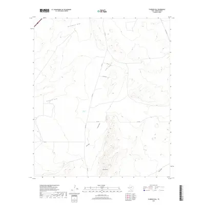
2019 Map of Florenzo Hill
USGS Topo · Published 2019About this map
Florenzo Hill rises as a prominent landmark in this Reeves County landscape, characterized by the intricate drainage networks of the Chihuahuan Desert. The terrain is defined by a series of significant ephemeral watercourses, including the expansive Billingslea Draw to the north and Ninemile Draw which cuts across the western portion of the quadrangle. A vital water source in this arid environment is noted at Ninemile Spring, located near the center of the survey area.
Find a feature on this map
14 named features on this map. Tap any name to fly to it.
Don’t see what you’re looking for? This feature index may not catch every label — zoom into the map to look around manually.
Map Details
Editions of this 2019 Florenzo Hill Map
This is the sole edition of this map. No revisions or reprints were ever made.
Other maps of this area

1921 · Toyah
USGS Topo · 1:125,000

1954 · Pecos
USGS Topo · 1:250,000

1955 · Saragosa
USGS Topo · 1:62,500

1957 · Pecos
USGS Topo · 1:250,000

1970 · Hermosa SW
USGS Topo · 1:24,000

1970 · Florenzo Hill
USGS Topo · 1:24,000

1970 · Toyah
USGS Topo · 1:24,000
1970 · Gozar
USGS Topo · 1:24,000
1970 · Toyah SW
USGS Topo · 1:24,000
1970 · Sotol Hill
USGS Topo · 1:24,000