
1952 Map of Florida
USGS Topo · Published 1953About this map
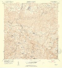
Florida and the surrounding agricultural valleys of northern Puerto Rico appear here during a period of transition in the early 1950s. The landscape is defined by an intricate network of haciendas, including Hacienda San José, Hacienda Santa Bárbara, and Hacienda Flor de Alba, which reflect the region's deep-rooted plantation history. Education and community life are anchored by the Escuela Segunda Unidad de Mameyes and Escuela Segunda Unidad de Frontón, marking the rural social centers of the era.
Find a feature on this map
67 named features on this map. Tap any name to fly to it.
Don’t see what you’re looking for? This feature index may not catch every label — zoom into the map to look around manually.
Map Details
Editions of this 1952 Florida Map
2 editions found
Other maps of this area

1942 · Manati
USGS Topo · 1:30,000

1942 · Arecibo
USGS Topo · 1:30,000

1942 · Barceloneta
USGS Topo · 1:30,000

1943 · Utuado NE
USGS Topo · 1:10,000

1946 · Barceloneta
USGS Topo · 1:30,000

1946 · Utuado
USGS Topo · 1:30,000

1946 · Ciales
USGS Topo · 1:30,000

1946 · Jayuya
USGS Topo · 1:30,000

1946 · Arecibo
USGS Topo · 1:30,000

1946 · Florida
USGS Topo · 1:30,000
Featured Places
- Florida, Florida
- Montaña, Arecibo
- Hacienda San José, Arecibo
- Cruce Cialitos, Ciales
- Sector El Hueco, Jayuya