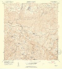
1952 Map of Florida
USGS Topo · Published 1953About this map
Agricultural haciendas define the mid-century landscape of this Puerto Rican interior, particularly throughout the barrios of Mameyes Arriba, Florida Adentro, and Sabana Hoyos. Centered on the town of Florida, the map details a region transitioning from its deep coffee and agricultural roots as aerial surveys from the 1940s meet the updated administrative oversight of the 1950s. The terrain is marked by numerous family-named estates such as Hacienda San José, Hacienda Las Abras, and Hacienda Flor de Alba, which serve as critical markers for local genealogical research.
Find a feature on this map
75 named features on this map. Tap any name to fly to it.
Don’t see what you’re looking for? This feature index may not catch every label — zoom into the map to look around manually.
Map Details
Editions of this 1952 Florida Map
2 editions found
Other maps of this area

1942 · Manati
USGS Topo · 1:30,000

1942 · Arecibo
USGS Topo · 1:30,000

1942 · Barceloneta
USGS Topo · 1:30,000

1943 · Utuado NE
USGS Topo · 1:10,000

1946 · Barceloneta
USGS Topo · 1:30,000

1946 · Utuado
USGS Topo · 1:30,000

1946 · Ciales
USGS Topo · 1:30,000

1946 · Jayuya
USGS Topo · 1:30,000

1946 · Arecibo
USGS Topo · 1:30,000

1946 · Florida
USGS Topo · 1:30,000