1947 Map of Florida NE
USGS Topo · Published 1947About this map
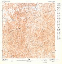
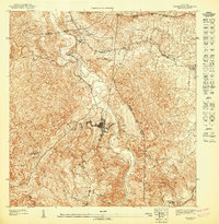
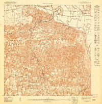
Montebello and the surrounding highlands are captured in this preliminary study based on 1943 topography. The landscape is defined by the complex intersection of the Municipio de Manatí Municipio de Ciales and Municipio de Barceloneta Municipio de Ciales boundaries, showing a rural region dependent on steep terrain and dispersed settlements like Camarones and Negrito. Foot travel and local transport are evidenced by the winding path of Camino Ceiba, which navigates the ridges above the valley of Quebrada del Pozo Azul. These small watercourses, including Los Caños and the Río Cialitos, dictate the settlement patterns of the 1940s, where small clusters of buildings are perched along the high ground between deep ravines.
Find a feature on this map
10 named features on this map. Tap any name to fly to it.
Don’t see what you’re looking for? This feature index may not catch every label — zoom into the map to look around manually.
Map Details
Editions of this 1947 Florida NE Map
This is the sole edition of this map. No revisions or reprints were ever made.
Other maps of this area

1942 · Manati
USGS Topo · 1:30,000

1942 · Barceloneta
USGS Topo · 1:30,000

1946 · Barceloneta
USGS Topo · 1:30,000

1946 · Ciales
USGS Topo · 1:30,000

1946 · Florida
USGS Topo · 1:30,000
1946 · Manati
USGS Topo · 1:30,000
1947 · Barceloneta SO
USGS Topo · 1:10,000
1947 · Ciales SO
USGS Topo · 1:10,000
1947 · Ciales NO
USGS Topo · 1:10,000
1947 · Barceloneta SE
USGS Topo · 1:10,000
Featured Places
- Los Quemaos, Florida
- Parcelas Arroyo, Florida
- Rafael Arroyo, Florida
- Vegas de Florida, Florida
- Estancias de Arroyo, Florida