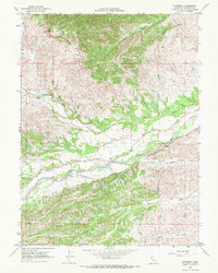
1967 Map of Flournoy
USGS Topo · Published 1972About this map
The small ranching community of Flournoy sits at the base of the foothills where the Sacramento Valley begins its rise toward the coastal range. This 1967 survey captures the rural layout of southwestern Tehama County, centered on the Flournoy Sch and the lifeblood of Thomes Creek. A significant historical landmark, the Nome Lackee Indian Reservation Monument, is noted near Mill Creek, marking a site of complex California history and indigenous displacement. An Indian Treaty Boundary line runs diagonally across the landscape, cutting through sections of rugged terrain near Table Mountain. The map details a network of ranch roads and jeep trails, including Osborn Road and Weston Road, which provided access to the remote creeks and hollows of the region. The landscape is characterized by its drainage patterns, with McClure Creek and Houghton Creek carving through the varying elevations.
Find a feature on this map
30 named features on this map. Tap any name to fly to it.
Don’t see what you’re looking for? This feature index may not catch every label — zoom into the map to look around manually.
Map Details
Editions of this 1967 Flournoy Map
2 editions found
Other maps of this area

1890 · Red Bluff
USGS Topo · 1:250,000

1894 · Red Bluff
USGS Topo · 1:250,000

1944 · Flournoy
USGS Topo · 1:62,500

1949 · Colyear Springs
USGS Topo · 1:62,500

1951 · West of Gerber
USGS Topo · 1:24,000

1952 · Red Bank
USGS Topo · 1:24,000

1952 · Paskenta
USGS Topo · 1:62,500

1952 · Red Bank
USGS Topo · 1:62,500

1957 · Colyear Springs
USGS Topo · 1:62,500

1957 · Ukiah
USGS Topo · 1:250,000