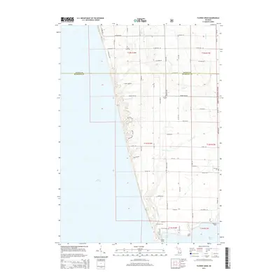
2014 Map of Flower Creek
USGS Topo · Published 2014About this map
Lake Michigan dominates the western shoreline of this coastal Muskegon and Oceana County landscape, where the waters of Flower Cr and Little Flower Cr carve through the terrain toward the lake. The map details a rural network of roads such as S Scenic Dr and Old Highway 99 that connect scattered family cemeteries, including Flower Creek Cem and Hubbard Cem. To the south, the geography transitions into the protected acreage of the Manistee National Forest and the wetland environment surrounding Pierson Drain. The southern edge reveals the complex coastal interface of Indian Bay and White Lake, defined by prominent landmarks like Indian Point and Dowies Point. This survey captures the area's transition from open forest and drainage basins to the developed waterfront communities established along the Lake Michigan bluffs.
Find a feature on this map
64 named features on this map. Tap any name to fly to it.
Don’t see what you’re looking for? This feature index may not catch every label — zoom into the map to look around manually.
Map Details
Editions of this 2014 Flower Creek Map
This is the sole edition of this map. No revisions or reprints were ever made.
Other maps of this area

1929 · Montague
USGS Topo · 1:48,000

1931 · Hart SE
USGS Topo · 1:31,680

1954 · Milwaukee
USGS Topo · 1:250,000

1958 · Milwaukee
USGS Topo · 1:250,000

1959 · Montague
USGS Topo · 1:62,500

1959 · Hart
USGS Topo · 1:62,500

1976 · Montague NW
USGS Topo · 1:24,000

1976 · Montague SW
USGS Topo · 1:24,000
1976 · Hart SE
USGS Topo · 1:24,000
1976 · Montague NE
USGS Topo · 1:24,000