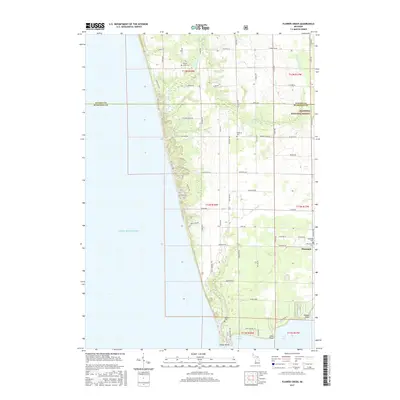
2017 Map of Flower Creek
USGS Topo · Published 2017About this map
The eastern shore of Lake Michigan defines this landscape, where the shifting sands and coastal drainage of Muskegon and Oceana Counties meet. This 2017 survey captures the interface of the Manistee National Forest and the northern edge of Montague, providing a detailed look at the rural property grid and coastal geography of West Michigan. Local history and genealogy are anchored by several established burial grounds, including Flower Creek Cem, Hubbard Cem, and the cluster of Oakwood Cem and Oak Grove Cem near the town limits. The map follows the complex path of Flower Creek and its tributaries, such as the N Br Flower Cr, as they wind toward the lake. At the southern edge, the map reveals the intricate shoreline of White Lake, marked by prominent features like Indian Point, Long Point, and Dowies Point, illustrating the area’s longstanding relationship with the waterfront and its recreational and residential development.
Find a feature on this map
67 named features on this map. Tap any name to fly to it.
Don’t see what you’re looking for? This feature index may not catch every label — zoom into the map to look around manually.
Map Details
Editions of this 2017 Flower Creek Map
This is the sole edition of this map. No revisions or reprints were ever made.
Other maps of this area

1929 · Montague
USGS Topo · 1:48,000

1931 · Hart SE
USGS Topo · 1:31,680

1954 · Milwaukee
USGS Topo · 1:250,000

1958 · Milwaukee
USGS Topo · 1:250,000

1959 · Montague
USGS Topo · 1:62,500

1959 · Hart
USGS Topo · 1:62,500

1976 · Montague NW
USGS Topo · 1:24,000

1976 · Montague SW
USGS Topo · 1:24,000
1976 · Hart SE
USGS Topo · 1:24,000
1976 · Montague NE
USGS Topo · 1:24,000